Geospatial Solutions
Expertise in open-source and commercial geospatial technologies to process, analyze, visualize, and interact with geospatial data at any scale.
Evaluating your needs: The right tool for the right job
Unlike product companies that focus on selling a specific product or platform, as a professional services firm, Prominent Edge is impartial to any specific geospatial technology. Our expertise spans a wide range of both open source and commercial geospatial technologies, with a solid understanding of the advantages and benefits of each. Our objective evaluation of your goals, constraints, and existing systems enables us to offer an unbiased recommendation specifically geared to your unique needs.
Get Started Now
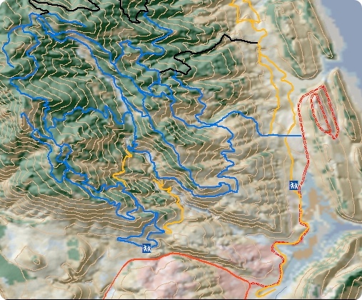
Custom Geospatial Solutions
Our expertise in geospatial solutions and Geographic Information Systems (GIS) includes a wide array of technologies and capabilities that we leverage to provide situational awareness, context, and location based services. Specific areas of expertise include:
- Browser-based, desktop, and mobile spatio-temporal solutions
- Solutions that leverage open source geospatial technologies (e.g., PostGIS, Mapbox, OpenLayers, GeoServer, and more)
- Solutions that leverage ESRI Server and other commercial technologies
- Highly scalable, serverless solutions that employ technologies such as vector tiles and Cloud-optimized GeoTIFFs
- 2D and 3D (e.g., Cesium, WebGL) geospatial visualization capabilities
- Infrastructure for disconnected or limited connectivity environments
- Integration of real-time sensor feeds, streaming data, and Internet of Things (IoT)
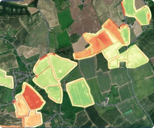
Geospatial Analytics
Geospatial analytics incorporate the valuable dimensions of location and time into your data to offer a more complete picture of events, yielding insights that become more readily apparent in a geospatially-enabled context. Geospatial analytics rely on georeferenced raster and vector data, leveraging today's ubiquitous array of location-aware technologies and spatially-enabled data sources. At Prominent Edge, we employ distributed technologies (such as Spark, GeoWave, GeoMasa, GeoTrellis, and ElasticSearch) to develop analytics that can achieve your objectives.
Get Started Now
Geospatial Support Packages
As experts and active members of the open-source geospatial community, we provide clients who prefer the GeoServer/PostGIS/QGIS stack with easy to deploy distributions, helpdesk, bug fixes, operations support, professional services, and more to meet their needs. Our support offering includes high-availability clustered deployments.
Learn More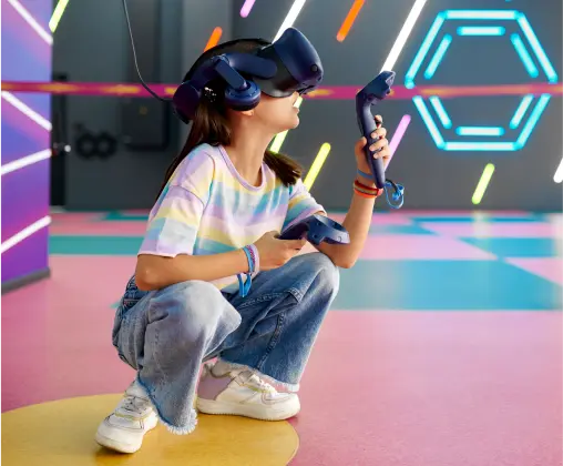
3D Applications, Gaming, and AR/VR
We have expertise building effective 3D web and mobile games and simulation leveraging technologies such as Cesium, WebGL, OpenGL, and game engines such as Unity and the Unreal game engines. We present the benefits of both 2D vs 3D approaches and also to help you select solutions that best fit your needs. Our strong understanding of geospatial, temporal, and what can be done on the front-end vs the backend will benefit you in building the appropriate Web, Mobile, and Desktop solutions.
Get Started NowOther services.
Need more than just Geospatial Solutions? We offer a full range of other services, including:

Analytics & Visualization
Gain actionable insights from analyzing and visualizing volumes of data to improve your bottom line.
Learn More
DevOps & Automation
We automate development processes that power fast and reliable releases, saving you money!
Learn More
User Experience Design
We build delightful user experiences by taking the time to understand you and your customer's goals.
Learn More
Web & Mobile
We design and build intuitive, easy-to-use, and scalable solutions for all web and mobile clients.
Learn MoreA sampling of our work.
StatEngine
StatEngine is a real-time open source data analytics and visualization platform for public safety organizations.
NASA
Our contributions help NASA monitor the telescope and see where it is in space. It’s space GIS. WHOA.
Underwriters Lab
We worked with UL to develop an innovative learning management system to increase firefighter knowledge to reduce injuries and deaths in the fire service and their communities.
AR / VR Technologies
We’ve developed facial recognition technologies used to identify and processes individuals in both connected and disconnected environments.
The CDC
In partnership with the Center for Disease Control, we help collect cancer data that enables data scientists to predict and decrease cancer outcomes of first responders.
Digital Streaming
We’ve developed an international audio and video streaming platform for delivering rich content to podcast listerners in difficult to reach and restricted locations.
Interested in working together?
We’d love to discuss how we can work together.